

- Lizenzbestimmungen
- Do What the Fuck You Want to Public License (WTFPL)
- Empfohlene OMSI-Version
- Aktuell v2.3.x
- Vorausgesetzte kommerzielle Erweiterungen
- Keine

-
1.0.0
- 223,82 MB
- 1,6k Downloads
-

A real hidden gem!
- DROGE
- 1.0.0
EN:
No reviews, no comments, no images, no description. I don't know know what drew me to try this map but I'm glad I did.
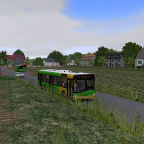
What we have here is a nice, little rural, Polish overland map. It's nicely made and pretty. It doesn't have constant, exaggerated twists and turns, like so many of the German overland maps. It's more realistic than that. There is 1 line, with a 20min running time.
Not everything was perfect - the two TTR files (for each direction) were not joined on the same spline, so there was no "smooth transition" in the timetable, but I was easily able to correct this. Also, oddly, there was only a 'Bus entry point' at one end of the route. But I easily added a new entry point at the other end. I also added some additional scenery at the terminus at one end (near the lake), as it was very sparse.
With 30 mins of enjoyable editing, I now have a well-running, functional overland map. Great for when you want a casual run.Recommended but only if, like me, you're able to fix a few of the errors.
-----------------------------------------------------------------------------------------
DE:
Keine Bewertungen, keine Kommentare, keine Bilder, keine Beschreibung. Ich weiß nicht, was mich dazu bewogen hat, diese Karte auszuprobieren, aber ich bin froh, dass ich es getan habe.
Was wir hier haben, ist eine schöne, kleine ländliche polnische Überlandkarte. Es ist schön gemacht und hübsch. Es gibt keine ständigen, übertriebenen Wendungen wie so viele deutsche Überlandkarten. Es ist realistischer. Es gibt 1 Zeile mit einer Laufzeit von 20 Minuten.
Nicht alles war perfekt – die beiden TTR-Dateien (für jede Richtung) waren nicht auf demselben Spline verbunden, sodass es im Zeitplan keinen „reibungslosen Übergang“ gab, aber ich konnte dies problemlos korrigieren. Außerdem gab es seltsamerweise nur an einem Ende der Strecke einen „Bus-Einstiegspunkt“. Aber ich habe am anderen Ende problemlos einen neuen Einstiegspunkt hinzugefügt. Außerdem habe ich an der Endstation an einem Ende (in der Nähe des Sees) etwas zusätzliche Landschaft hinzugefügt, da diese sehr karg war.
Nach 30 Minuten unterhaltsamer Bearbeitung habe ich jetzt eine gut funktionierende, funktionsfähige Überlandkarte. Ideal für einen entspannten Lauf.
Empfohlen, aber nur, wenn Sie wie ich in der Lage sind, einige der Fehler zu beheben.