

- Lizenzbestimmungen
- Creative Commons <by-nc-nd>
- Empfohlene OMSI-Version
- Aktuell v2.3.x
- Vorausgesetzte kommerzielle Erweiterungen
- Keine
->Thanks to naftalinov for permission to upload the program to the OMSI WebDisk<-
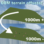
This tool provides you with the opportunity to change the elevation of the terrain (by a desired number of metres) of the whole map in OMSI, leaving all hills, mountains and plains the same as the original ones. Note, that it cannot change the elevation of a custom map, where the user has created his/her own shape of the terrain - custom hills, flat areas, etc. It will not keep intact any changes to the shape of the earth, made by the user after using the DEMImport system of Omsi Editor as well. It was designed by me to be used when importing real-world relief of the earth into a new map.
But first, let me tell you why I did this thing, called "DEM terrain offsetter". I found out, that I can put splines anywhere, at any elevation, but I cannot put objects at elevations greater than 1000 metres above sea level. This can be really frustrating, especially if you want to make a map of a high mountain pass (most of them are around or even more than 2000 metres high). This just limits your imagination. At first, I started to look for mountain roads below 1000 metres. But this is like searching for a sport's car, that consumes less than 10 letres per 100 km and has less than 150 hp. It may still accelerate relatively quickly, but it's not a sport's car, you know what I mean.
So at first, I started to investigate the .terrain file of a tile of the template map, used many different heights (tab "Terrain" -> radio button "Set height to"), each time saving the map and checking the differences in the .terrain file. This way, in a matter of hours, I managed to find out how the elevation for each point of the map is saved. But then I realized, that there is a bigger .rdy file, which has to be examined as well (if I edit the .terrain file only, nothing changes). That's why I focused on the .hgt files, which contain the elevation data of the real world. So I came up with the idea to modify this sourcing .hgt file (because this is the source of information for the elevation if you plan to create a real-world map) and in this way to achieve lowering of the whole map. The idea is - if I plan to create Stelvio Pass, for example, its elevation is between 1200 and 2750 metres. No way I can place a single object on this map without offsetting the elevation of the whole map. And then, a couple of days of coding, debugging and testing later I came up with this - the DEM terrain offsetter! Using it, I managed to lower the elevation of the whole map by 1800 metres, so now it's elevation is between 600 metres below sea level and 950 metres above sea level. And the whole scenery remained intact - mountains, valleys, etc. Now I can put objects anywhere. Yey! ![]()
So that's it. Thanks for reading all this. I hope you find this little tool useful and hope you like it! ![]()
(This program can be used in any other game)
Bilder


-
1.0.0
- 8,43 kB
- 172 Downloads
Hamburg
auch wenn OMSI und Berge nicht so gut zusammenpassen ist dies ein wirklich nützliches Tool!