

- Lizenzbestimmungen
- Do What the Fuck You Want to Public License (WTFPL)
- Empfohlene OMSI-Version
- Aktuell v2.3.x
- Vorausgesetzte kommerzielle Erweiterungen
- Keine
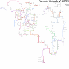
Routemap of Stadsregio Vlietlanden from Mr.Drive, which can be found at https://stadsregiovlietlanden.nl/
Locations on the map are extracted from tiles and tile positions, so the spatial layout is close to 1:1.
While this doesn't serve the traditional purposes of such a map, I have found it to be helpful as a driver to get a spatial understanding of the map and routes.


-
Map Xtreme - image v0.1
- 313,9 kB
- 141 Downloads
Routemap of the Stadsregio Vlietlanden map as of the definitive version, known as Xtreme
Not fully refined but I hope it's still clear enough to give some context to the layout of this ginormous map.
-
Map v4 - image v0.1
- 322,76 kB
- 29 Downloads
This is the routemap of the Stadsregio Vlietlanden map as of version 4.0
I did not get around to refining it fully, so excuse any overlapping lines and text.
-
Map v3.5 - image v1
- 420,67 kB
- 555 Downloads
PNG version