
What do you think about the progress on the map so far? 45
-
Looking Beautiful! (27) 60%
-
It's getting there! (13) 29%
-
Needs a bit of work! (5) 11%
Welcome to Washington!
Located on the west coast of the United States and regarded as the Evergreen State, Washington is likely most well known for the large coast city of Seattle. However, Washington is also home to some of the Pacific Northwest's biggest and most beautiful national parks. Established in 1899, Mount Rainier National Park is a key icon of Washington State. The park is highly visited, with over 1.5 million parkgoers in 2018.
This OMSI 2 map will be a semi-fictional map based on Mount Rainier National Park. You'll be able to drive along the famous Interstate 5 from Chehalis and Centralia, then travel across the state on US-12 towards the national park. The map will be geographically realistic, but the routes and scenery will be fictional. The first version of the map will feature three routes:
Salish Express
This route serves as a connector between Centralia and Mount Rainier National Park, stopping at 2 small towns along the way. Serviced by coach buses and operated as a subsidiary of Sound Transit, the Salish Express operates half hourly to hourly services to the park. The journey time is about 65 minutes and covers over 35 miles (55 kilometres), including stretches on the I-5, US-12, WA-7, and WA-706.
Shuttle Routes
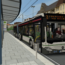
The green line services the visitors centre at Mount Rainier and travels along, steep and narrow roads towards trailheads, campgrounds, and other nearby attractions. These are services by 30-35 feet buses such as the Gillig Advantage, although Sound Transit has also ordered several MB O520 Cito buses for use on this route.
The white line transports passengers from the visitors centre to Mount Rainier Ski Resort. During the summer, the ski resort turns into a mountain biking and hiking park.
A future version of the map will also include the red line, which will transport passengers to the nearby Glacier Adventure Centre.
Network Plan
The following map shows the route network that is planned for the map.
Our Mission
Our development team's goal is to produce a completely new American OMSI 2 map which heavily focuses on detailed scenery and an authentic experience. We would love to get the community involved and make this map as much European as it is American, especially when we release our livery pack soon. We hope to cater to both the American OMSI community, with styles and AI that reflect American transit agencies, but also include support for European fleets and vehicles.
Help us gauge the interest from the community by rating the thread! It will be greatly appreciated!
Join us on Our Discord!
Regular updates and screenshots will be posted much quicker than on the forum! Click Here!
Screenshots
March 2021
A NorthWest Studios Project ~ reappearings tealts
(c) 2020 - 2021